Indian Scientists Track Greenhouse Gases in Himalayas, Unveil Key Climate Clues
To put the Himalayan data into context, researchers compared it with Mauna Loa, the world’s most referenced clean-air background site.
- Country:
- India
In a landmark climate research development, Indian scientists have, for the first time, successfully recorded continuous, high-resolution, real-time measurements of critical greenhouse gases — carbon dioxide (CO₂), methane (CH₄), and carbon monoxide (CO) — from a high-altitude site in the Central Himalayas. This pioneering effort offers invaluable insight into how natural processes and human activities collectively influence atmospheric chemistry in one of the world’s most climate-sensitive regions.
The study was conducted by the Aryabhatta Research Institute of Observational Sciences (ARIES), an autonomous institution under the Department of Science and Technology (DST), Government of India. The multi-year dataset, gathered from a dedicated research facility in Nainital, helps bridge a longstanding gap in ground-based atmospheric monitoring across South Asia's mountainous terrain, long overshadowed in global climate networks.
A Himalayan Milestone in Greenhouse Gas Monitoring
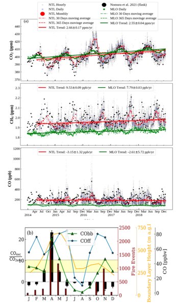
Led by Dr. Priyanka Srivastava and Dr. Manish Naja, the research team collected and analyzed atmospheric data between 2014 and 2018. Their findings reveal how both biospheric processes (like photosynthesis and vegetation cycles) and anthropogenic activities (like agriculture, biomass burning, and fossil fuel use) are shaping the concentrations and seasonal patterns of greenhouse gases in the region.
The Himalayan vantage point of Nainital, located far from major urban sources yet close enough to detect regional emissions, allowed researchers to disentangle overlapping environmental influences — from daily wind-driven pollutant transport to seasonal agricultural practices and long-range pollution carried from the Indo-Gangetic plains.
Key Findings: Daily and Seasonal Patterns
The study documented distinct diurnal and seasonal variability in all three gases:
Carbon Dioxide (CO₂)
-
Lowest levels observed during daylight hours due to photosynthetic absorption by vegetation.
-
Seasonal peak in spring, likely due to biomass burning and limited vegetation cover.
-
Long-term trend shows steady annual increase of 2.66 ppm, higher than the increase observed at the global background site Mauna Loa in Hawaii.
Methane (CH₄)
-
Daytime peaks, likely from upslope winds carrying pollutants from agricultural lands.
-
Highest seasonal concentrations in autumn, attributed to post-harvest agricultural activities, especially rice cultivation.
-
Increasing annually by 9.53 ppb, again exceeding Mauna Loa’s trend.
Carbon Monoxide (CO)
-
Daily peaks during the day, indicating transport from lower elevations.
-
Seasonal spike in late spring, consistent with regional biomass burning and pollution transport.
-
Shows a gradual decline of 3.15 ppb per year, potentially indicating improved combustion technologies or a shift in emission patterns.
The Role of Environment and Weather
Importantly, the study highlights how solar radiation, temperature, and boundary layer dynamics — the layer of the atmosphere closest to Earth’s surface — play as significant a role in shaping greenhouse gas variability as human-made sources. These environmental drivers control how pollutants mix, disperse, or remain trapped near the surface.
The atmospheric boundary layer height, in particular, was found to regulate how much of the lower-atmosphere pollutants were retained or diluted throughout the day, emphasizing the complex interactions between meteorology and emissions.
Comparing Global Background Trends
To put the Himalayan data into context, researchers compared it with Mauna Loa, the world’s most referenced clean-air background site. Surprisingly, the Central Himalayas show faster increases in CO₂ and CH₄, though absolute concentrations remain lower than urban or semi-urban locations. This underlines the regional acceleration of climate-affecting emissions and the need for localized climate action in South Asia.
Scientific and Policy Implications
These ground-based observations are crucial for climate validation and mitigation, especially in a region undergoing rapid socio-economic and land-use changes. The data can:
-
Validate and calibrate satellite-based greenhouse gas measurements
-
Improve emissions inventories for national reporting
-
Strengthen forecasting models for regional climate and air quality
-
Support evidence-based climate policy and international commitments
Furthermore, the findings empower policymakers with accurate, high-resolution data, allowing for targeted interventions — whether in agriculture, energy use, forest management, or transport.
Toward a Resilient and Data-Driven Future
This study is not only a scientific breakthrough but also a call to action. With the Himalayas acting as both a climate regulator and vulnerable frontier, sustained ground observations are vital for tracking progress toward climate goals.
As South Asia navigates its climate challenges, the ability to monitor, understand, and respond to localized emissions will be key. The ARIES team’s work stands as a foundation for future climate research in the region and offers a blueprint for integrating observational science with policy planning.


