AI-powered drones revolutionize animal tracking, but data limitations remain
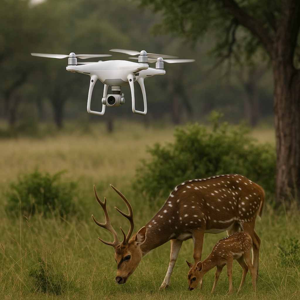
The integration of UAVs and AI is enabling faster, safer, and more scalable ecological surveillance. Multirotor drones offer maneuverability in dense habitats, while fixed-wing drones cover vast areas efficiently. Equipped with visible, thermal, and hyperspectral sensors, drones collect data on animal presence, movement, and environmental conditions in ways previously inaccessible to researchers. These massive datasets are then interpreted using deep learning models, which automate classification, object detection, and behavioral pattern recognition.
Unmanned aerial vehicles (UAVs) are redefining the future of wildlife conservation, delivering real-time intelligence from rainforests to savannas. However, a new study warns that while drones powered by artificial intelligence (AI) are transforming species identification, tracking, and anti-poaching surveillance, they remain constrained by technical, ecological, and regulatory hurdles that could undercut their long-term effectiveness.
The study, “Drones and AI-Driven Solutions for Wildlife Monitoring”, published in Drones, provides a comprehensive review of 97 scientific papers from 2018 to 2025. It evaluates the integration of drone platforms with machine learning and deep learning tools across five key domains: species identification, animal tracking, anti-poaching, population estimation, and habitat analysis. The findings highlight how these technologies are augmenting traditional ecological methods, while also revealing systemic gaps in data quality, scalability, and operational reliability.
How are drones and AI transforming wildlife monitoring?
The integration of UAVs and AI is enabling faster, safer, and more scalable ecological surveillance. Multirotor drones offer maneuverability in dense habitats, while fixed-wing drones cover vast areas efficiently. Equipped with visible, thermal, and hyperspectral sensors, drones collect data on animal presence, movement, and environmental conditions in ways previously inaccessible to researchers. These massive datasets are then interpreted using deep learning models, which automate classification, object detection, and behavioral pattern recognition.
In the domain of automated species identification, models like YOLOv4, Faster R-CNN, and ResNet achieved detection accuracy ranging from 80% to 99% across diverse species including caribou, Bengal tigers, deer, koalas, and bats. For cryptic and nocturnal species, thermal imaging fused with advanced AI models proved especially effective, significantly improving detection rates. GANs were even used to identify over 30 bat species in complex aerial data streams.
Tracking and behavioral analysis have similarly evolved. AI-enhanced telemetry, real-time pose estimation systems such as DeepPoseKit, and multi-animal tracking tools like IDTRACKER.AI enable researchers to observe foraging, migration, and group dynamics. Drones combined with reinforcement learning and swarm coordination algorithms also improve tracking of fast-moving or evasive wildlife, from zebras in savannas to primates in forests.
In anti-poaching operations, AI-integrated drones are automating surveillance, even under dense canopy cover or at night. Studies demonstrated that drones using YOLO-based object detection, thermal imaging, and GAN-enhanced classifiers could reliably detect intruders and endangered animals with up to 98% accuracy. Swarm-enabled search systems and edge-computing frameworks like WatchEDGE further expand surveillance capacity across challenging terrains.
Population estimation has also seen significant improvement. Drones allow researchers to perform large-scale aerial counts of birds, mammals, and marine species. Machine learning models automate nest detection, species classification, and behavioral annotation—delivering results five times faster than traditional fieldwork. Some tools, like the DenoiSeg segmentation algorithm, reduce the time to count 100 birds from over a minute to just 7 seconds. In thermal image-based surveys, precision counting of elusive species like elk and sika deer has become increasingly viable.
Finally, in habitat analysis, drones equipped with multispectral sensors assess forest health, vegetation density, and ecosystem stressors. AI models predict wildfire risks, detect invasive plant species, and estimate crop damage. In marine systems, drones monitor algal blooms, fish stocks, and coastal degradation with increasing accuracy.
What technical and ecological limitations are slowing progress?
Despite the significant advances, the study identifies several barriers preventing widespread and equitable deployment of drone-AI systems in conservation.
One major concern is dataset bias. Most available data are skewed toward large mammals in African and North American ecosystems, while tropical, nocturnal, and smaller species remain underrepresented. This lack of diversity reduces model generalizability across habitats and species, weakening the robustness of AI systems when applied to new or sensitive ecological zones.
Technical hurdles also persist. Drones face limited battery life, connectivity issues in remote regions, and degraded image resolution at higher altitudes. Complex habitats with dense foliage cause occlusion, complicating object detection. Moreover, thermal imaging, critical for nighttime or camouflaged species, declines in accuracy beyond certain altitudes, such as above 120 meters.
AI models, especially deep neural networks, require extensive annotated data and computing power. Edge computing offers real-time inference but remains constrained by payload, energy consumption, and hardware limitations. Autonomous drone swarms and hybrid air–ground systems are emerging, but they demand reliable 5G or LoRaWAN connectivity and remain cost-prohibitive for many research groups.
Behavioral ecology also presents unique challenges. While AI can track movement, distinguishing behaviors (e.g., stress, social interaction) still requires human expertise. Markerless pose tracking at scale remains computationally demanding, and observer effects, including stress caused by drone presence, must be mitigated through species-specific protocols.
What’s needed for the next generation of drone-AI wildlife tools?
To move forward, the study calls for a three-pronged strategy: data collaboration, technical advancement, and ethical deployment.
Collaborative platforms such as LILA BC, Conservation AI, and Wildlife Insights are central to building diverse, high-quality datasets. Integrating drone data with GPS telemetry (via Movebank) or satellite data (via GBIF or EarthRanger) can support federated learning and transfer learning strategies, reducing dependence on large training sets.
Technically, future solutions must leverage multi-sensor fusion, edge AI processors, and lightweight pretrained foundation models tailored to ecological data. Hybrid drone networks with swappable sensors, combined with adaptive flight planning and onboard processing, could allow persistent real-time surveillance in remote and extreme environments. Quantum-inspired algorithms and self-optimizing UAV paths will push the frontier of fully autonomous wildlife monitoring.
Equally important are ethical safeguards. Researchers must adhere to regional aviation laws, such as U.S. FAA restrictions or EU EASA regulations, and obtain permits to operate drones in sensitive zones. Ecological protocols, like avoiding flight during mating or nesting seasons, using low-noise drones, and maintaining altitude thresholds, are critical to avoid harming vulnerable species.
The high cost of drone operations remains a final constraint. With equipment, permits, insurance, and training often totaling over USD 10,000, accessible deployment of these technologies requires funding partnerships, open-source tools, and training programs for under-resourced conservation groups.
- FIRST PUBLISHED IN:
- Devdiscourse


